We all headed off towards Exmouth. The plan was to camp up in a rest area 20 km short of the town but we discovered that it no longer existed so we had to press on into town and see what was available in the way of caravan park sites. In the event we were all able to get sites in the Ningaloo Caravan Park at CMCA discount rates (less than 50% of the normal rate) and we were able to set up a nice camp.
The Bettisons had cooked osso buco enough for us all so we dined al fresco with a couple of bottles of Bethany wine from my "cellar".
We had an extended morning tea catching up with everyone and then went into town to do a little shopping.
In the afternoon, I cooked curry for a communal dinner tomorrow night. Elsie did a chicken salad with noodles so we all dined out again.
I started the laundry early to get ahead of the crowd.
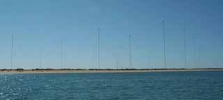
After lunch in town, we took a short drive up to the top of the Cape to see the North West Cape VLF Transmitter Station which is very imposing - it is 367 m (1204 feet) high and 2.5 km (1.6miles) in diameter. It communicates over immense distances with submerged submarines in the Indian Ocean. It used to be staffed by US and Australian servicemen in quite large numbers but now is run by the RAN with only a handful of personnel none of whom live on the base. Perhaps the collapse of the cold war has removed the need for covert communication but I don't see why you would not maintain a capability you once found necessary.
We also went to the Vlamingh Head Lighthouse to see the view over the entrance to Exmouth Gulf and some way down the Ningaloo Reef.
In the evening, we had eight to a curry dinner which was so well received that there was none left over.
I felt a bit crook so we had a lay day.
I still felt a bit crook so we had a another lay day.
I had birthday cards from people here and singing phone calls from people there for my birthday which was very nice.
We set off reasonably early to visit the Cape Range National Park.
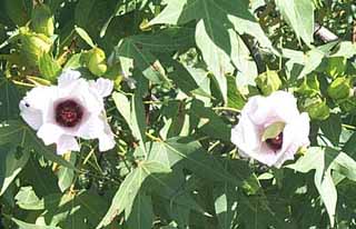
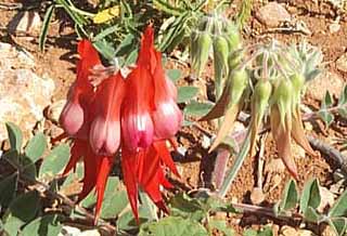
This park is most unusual in that all the highlights are hidden from view. The park takes in the ridge which runs down the centre of the peninsula, the shore which is a series of beaches, and the narrow strip of land between. The soil is largely sandy and the vegetation is almost exclusively very low scrub with occasional outbursts of wild flowers, Sturts Desert Pea which here has a red centre rather than the more usual black, desert roses, and a variety of unidentified small plants.
We drove down to the southern end at Yardie Creek and visited various beaches on the way back.
Yardie Creek is a small gorge which boasts a river cruise currently not operating. It is pretty unimposing after such places as Katherine Gorge.
We stopped at Osprey Bay and dipped our feet in the water but it was a bit cold for swimming. We came upon some friends who were camping there and chatted to them. They were enjoying their stay largely because there is nothing to do.
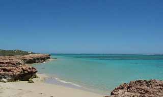
We went on to Turquoise Bay and stopped for lunch. There is a nice picnic shelter there overlooking the bay which is large and shallow with interesting looking rocks but there is a warning that there are dangerous rips taking the water back out beyond the reef. I suspect that this is a problem only in particular conditions of tide and weather but it rather puts a dampener on ones enthusiasm for swimming here.
We dropped into the visitors centre and enquired about the birds nest on top of the antenna tower. It is an abandoned Osprey nest. The birds raised chicks in it every year until a wind generator was installed nearby. The generator is no longer used but the birds haven't returned. This is a classic case of unexpected side effects of an attempt to improve the environment being worse than the problem being solved.
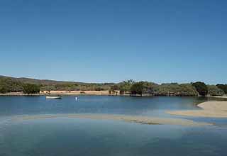
On the way back to town, we went to Bundegi beach where the gulf cruise boat is located and, though it had been very windy on the coast all day, the gulf was remarkably smooth so we decided to stay on in Exmouth and give the cruise a go.
Though our companions of the last few days have all gone, a new lot have appeared and happy hour was as lively as ever.
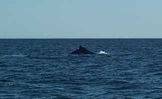
I rang the boat operators to find out if the weather was good enough to go out today. They said it was so we booked for the coral viewing and the whale watching this afternoon.
The trip started badly when the boat wasn't there when we arrived at the appointed time. They had cancelled the snorkelling part of the tour because the water wasn't clear enough so they had gone out looking for whales and had to come back to pick us up so we started out a bit later than advertised.
In the event, it didn't make any difference because we did the coral viewing as planned and then went out into the bay to look for whales.
The coral reef in the bay is just an extension of the reef on the ocean side of the peninsula. The boatman said that the coral here is more diverse in any one place whereas outside one sees patches of coral all of the same kind. I was impressed with the lack of colour and asked Jean if it was different from the Great Barrier Reef. She remembered being surprised then concerning the lack of colour having been led to expect something much more vibrant by all those nature documentaries.
We motored well out into the bay in search of whales. The females come into this safe place to give birth and stay here for several months to suckle the calves. We saw a blow and motored over to the vicinity where we were rewarded by a good view of a mother and calf slowly surfacing to breathe and gliding gently under the surface again. At times they disappeared for some minutes but we would see them again some way off and move position to see them fairly closely. At the end of the trip, the boatman apologised for the unco-operative whales because they sometimes provide a more immediate experience but we were all happy to have spent an hour or so in company with them. I wouldn't, however, recommend this cruise as it doesn't really live up to its promise.
We greeted the "family" who arrived from Onslow before morning tea and parked nearby. We prepared a packed lunch and headed south in the Little Motley to explore the inland bits of the Cape Range National Park.
Shothole Canyon is along a 13 km (8 mile) gravel road which wasn't too bad. When we got to the end, we had lunch in the shady of the biggest tree we had seen in the park, a 3 m (10 ft) mallee which had a picnic table set in its shade. The canyon is a strange place. The walls are characterised by odd curved sandstone overhangs which make it look as though it is peeping out at you.
Charles Knife Road, another ten or so kilometres south, is bitumen for the first 5 km (3 miles) which takes you up onto the top of a ridge between two canyons. The gravel road take you a few more kilometres to the park boundary. In some places the gap between the canyons is only just wide enough for the road and both sides plunge precipitously right down tho the canyon floors which is quite unnerving.
The road in the park takes one to the site of the first oil well on the North West Cape, unproductive but the fore-runner of the development of the whole North West Shelf development which now earns such a large part of Australia's export income. I had imagined that one could walk to the top of the ridge and look down on the coastal strip but I gave up when the first ridge only led to another valley and another ridge, and possibly another valley and another ridge, and . . . .
On the way back out of the park I noticed a side road signposted to a walking trail. We spent a few anxious minutes negotiating a pretty rough and narrow track but soon reached the lookout which does provide the expected view. Sadly it was a bit hazy so the view was muted but we got a good impression of the coastal bit of the park in panorama.
On the last stretch of road out of the park, at the top of the ridge, one gets a splendid view of Exmouth Gulf. Once again, the haze took something away from the scene but even so, I noticed that the far shore was still not in sight even from this elevation. The gulf is roughly 40 km (24 miles) wide so one would have to be only 125 metres ( 200 feet) up to see the far shore so the visibility must have been the problem.
Up at sparrowfart to do the laundry which was out on the line well before Jean woke up.
We decided to go back to Turquoise Bay to go snorkelling.
On the way we revisited the bird hide at Mangrove Bay. There were not many birds but we did see Grey-tailed Tattler, another new species for my list. We also stopped to check out a little lizard on the road. It was a Western Bearded Dragon, only about 20 cm (8 in) long and I encouraged it to leave the road and go into the bush where there was less risk of a fatal encounter with a motor vehicle.
The snorkelling at Turquoise Bay was wonderful. The water was warm and clear and the coral is only a few metres from the beach. We saw many different species of fish, most of which we couldn't identify but which included, Silver Trevally, Threadfin Butterflyfish, Painted Flutemouth, Eyed Skate, Neon Damsel, Midnight Angelfish, and Southern Drummer. We also saw clams, sea slugs and many kinds of coral.
We were both glad that we had decided to come back here to swim. The day will be one of the highlights of our journey to WA.