
Heavitree Gap, Alice Springs, NT
S 23°43'43" E 133°51'59
Mon 16 - Wed 18 Oct 2000
[Previous]
[Next]
[Bottom of Page]
[Index]
[Home]
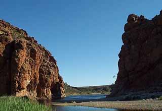 In the morning we inspected the gorge. It is the route of the Finke River through the range on its way to the south. There is a permanent lagoon just upstream of the gorge but there was still lots of water about from the Easter rains. There were supposed to be lots of water birds but we only saw a very few. I did see some Australian Reed Warblers which was a new species for me.
We turned back to the east and visited the sights in turn.
Ormiston Gorge is part of a fairly large impoundment in the range to the north of the road. We didn't have the fortitude to walk the full 9 km (6 miles) nor to climb to the Ghost Gum Lookout but we spent some time at the waterhole and marvelled at the height of the easter floods which were a good 3 m (10 ft) above the normal water level.
We visited the Ochre Pits which are still used by the first wave immigrants to provide colour for rock and body painting. The rock layers which provide the ochre are vertical and include several different colours of soft siltstone. Happily most people just look but some 2nd and 3rd wave immigrants seem to believe that leaving their personal mark in the rocks is somehow cool.
 We tried to get to Serpentine Gorge but the road was too bad and we had had our ration of off road work in the East McDonnells. We bypassed Ellery Creek and the Big Waterhole for the same reason.
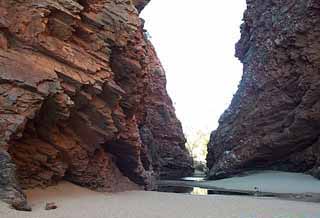
Simpsons Gap is very accessible and pretty impressive. There is a very strange phenomenon here which is not evident at the other gaps. For about 3 m (10 ft) above the level of the water in the waterhole, the rock is not its normal rust colour but is rather whitish pink. This is apparently the result of sandblasting of the rock during floods! Just imagine the amount of water that must be involved and try to get your mind round the incredible number of floods involved over some kind of geological time span. Remember that this is so called desert country.
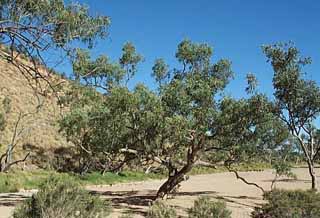 On the way back to the car park couldn't resist taking a picture of a typical River Red Gum, well not so much typical as archetypical. Of course the term river also means something different out here. Notice the broad stretch of river sand which constitute this river nearly all the time.
We returned o the caravan park at Heavitree Gap for a day or two's rest and relaxation
[Previous]
[Next]
[Top of Page]
[Index]
[Home]
Contact the webmaster
Created by Robin Chalmers on 26.10.2000 and last revised 08.11.2000