We awoke to find the view almost completely gone because the smoke from the big bush fire 50 km (30 miles) to the east had come in on the breeze. A ute with a yellow light came up and Jean was convinced we were about to be evicted by the ranger. It wasn't a ranger, it was Mad Ted, a timber cutter, come to check out the smoke. He gave me his (very poor) opinion of the CALM blokes who were supposed to be controlling the fire and he wished us a safe and pleasant journey.
I decided that, as we had a little time to kill, we should visit Kalgoorlie. The drive north was interesting because we were deep in mallee country and could well have been in north west Victoria. I don't quite know what I expected this part of the world to be like, but I didn't expect anything like this. The elevation here is about 300 metres (100 feet) and the bush looks very healthy with lots of big trees and plenty of green. We are out here to get an education in the geography of Australia and some of the lessons are really unexpected.
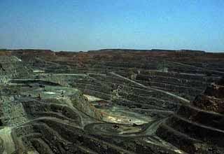
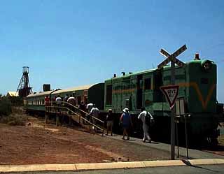
We took the Loop Line trip to see the Superpit gold mine. The train trip was a bit of a disappointment because it only goes a few kilometres to Kamballie and then comes back to Boulder City. The mine is pretty impressive. It is a 250 metres deep (600 feet) open cut mine which works 24 hours a day 365 days a year (24/7 in newspeak, I think). With a never ending string of 200 tonne ore trucks continuously going down to bottom of the pit and pulling slowly up again on the carefully maintained roads.
It got to be exceedingly hot so, after lunch, we veged out in the Motley.