Having cured the major problem with the Motley, we set off to do more site surveying for Philip. He had asked us to do the NSW stretch of the river between Mildura and Euston so we set off through Gol Gol along the main highway to Sydney.
We collected data and took photographs of all the sites we could find, leaving those down the dirt roads for a trip in the Little Motley. We had, after all, bought the Terios specially to give us easy access to the bush while sparing us the discomfort of the Motley's uncomfortable ride over gravel roads.
We had lunch at Bottle Bend which we had last visited in 1998. It is interesting to note that neither Jean nor I could remember it very well. We noticed that there were people camping on the Victorian side of the river. The maps of Victoria didn't provide any clue as to how they got there as there are no roads or tracks marked in the area. Perhaps it is one of those well-kept secrets which people protect to limit the number of visitors to their favourite spots.
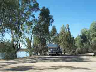
We arrived at Euston in time for lunch and fetched up by the river inn front of the Bowling Club which was identified in "the book" as the site of a free camp.
We went to the club for lunch to save cooking in the evening. The lunch special was two courses for $5 which is a bit of a bonus for retired nomads.
We had parked in view of the office and the receptionist told us that, as we were motorhomers, the manager would like to talk to us. When we had ordered our lunch, we introduced ourselves and he invited us to camp in the bush camping area behind the club.
He is an aspiring motorhomer and member of the Road Runners who is in process of converting a double-decker bus with plans to go on the road full time in a year or two. We chatted for some time and he asked us if we would like to do a trip "round the island" in boat of a friend, Phillip Cox who is just setting up a new business, Back Water Murray River tours.
We were happy to accept and in the evening we were taken on a "promotional" trip.
This was a very pleasant outing and the guide was very knowledgeable. He is a fourth generation river fisherman until the licences to fish the river professionally were not renewed a few years ago. He obviously loves the river and knows it intimately.
He was quite scathing about the Wentworth Group who have been lobbying for changes to the management of the river. His view is that their motives are venal in that they want to get control of water rights so that they can establish a "market" in which they can make money. He also says that their proposed solution to the rivers problems is a waste of effort. He also thinks that the proposed increases in the river flow will not be anything like enough to cure the problems of the river which needs regular big floods to provide the right environment for the native fish to breed in the safety of the dead wood on the flood plains He might be a bit biased, being a fisherman, but the considered views of those who live by and on the river are probably closer to the mark than those of city business men and their "technical advisers".
He had some interesting things to say about the fish in the river. He told us that there are plenty of native fish and that the carp are much less numerous than they were some time ago. It seems that if the water level in the river is dropped by just a few tens of centimetres (a foot) at the time when the carp spawn and leave there eggs attached to the river bottom just below the surface, many eggs die from exposure reducing the reproduction rate significantly.
We visited Lock 15, getting a new perspective on these structures from the river rather than from the land. They have replaced the fish ladder here with a new design to improve the chance of native fish reaching their preferred breeding grounds. Some of the fish here wear radio tracking devices and there is a data logger on the lock which keeps track of all the tagged fish which approach the weir.
We went right round Bumbang Island which is the result of a very large ox-bow bend the ends of which has been joined again by the river. The inaccessibility of the island has resulted in an environment which has been relatively free of human interference for a long time and which has returned to something like the original condition. Our guide was able to show us all sorts of interesting things including a regularly used sea eagle nest, many scar trees and shell middens showing evidence of earlier aboriginal occupation, and the signs of timber cutting from the days of the paddle steamers.
Our study of the Murray Darling river system was greatly enhanced by this unexpected and very welcome experience.
On Friday we did some site survey work. First we went west in the Little Motley looking for a couple of off road sites that we had bypassed on the way to Euston.
The first was the Euston State Forest. The directions in the "book" said it was at Euston on the Tapalin Mail Rd. On the way here we had noticed two signs to this road, one 30 odd km west of Euston and one 5 km west. We assumed that this site was on the nearest one so we went searching. We eventually found a sign "Euston State Forest" close to the main road with a very 4WD road going in. We searched for any where to camp but found several low overhanging trees not far from the entrance. The forest has oodles of space to camp if you are car sized but the low branches would restrict any decent sized rig to places quite near the road so I think it is a very iffy site.
The second was the Mallee Cliffs State Forest 40 km west of Euston on the Tapalin Mail Rd. I assumed that this site was on the other bit of this road so we drove 30 km back up the highway to the other turnoff. We couldn't find any sign to the Mallee Cliffs State Forest and finished up driving the whole length of the Tapalin Mail Rd, all gravel, and arrived back at the Euston State Forest without finding any other camping sites.
We did come across Mount Dispersion which is all of 20 m (60 ft) high but it has a monument which celebrates the meeting between Captain Sturt and an aborigine in 1836.
In the afternoon I went east to do a couple of site on the Balranald Rd.
In the evening, we dined in airconditioned comfort at the club